Use of GIS technology

N-340 roadway corridor project

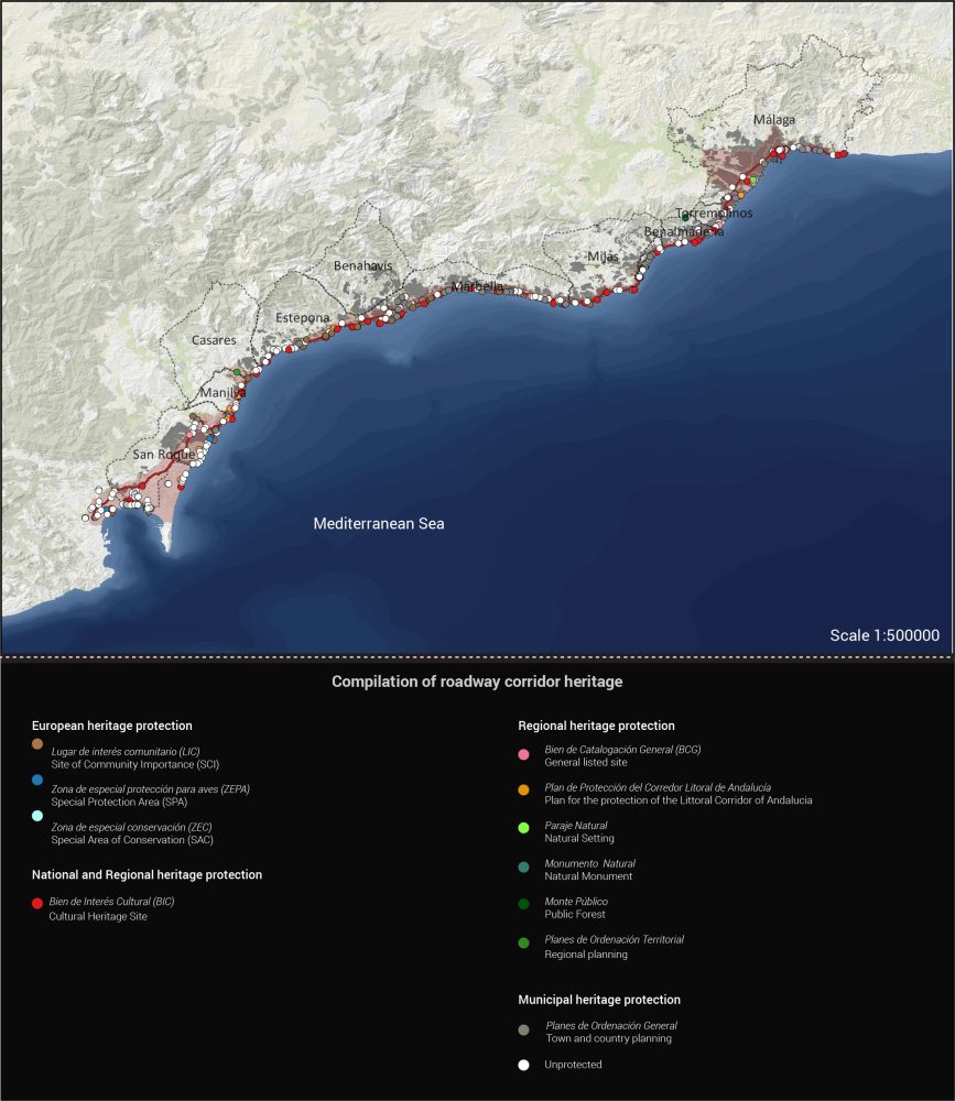
N-340 roadway corridor project Mar Loren Méndez - Principal researcher. Compilation of the heritage assets of the corridor. European, national, regional, and local heritage protection. Research results inserted into: IECA Topographical Map of Andalusia scale 1:400.000, 2008

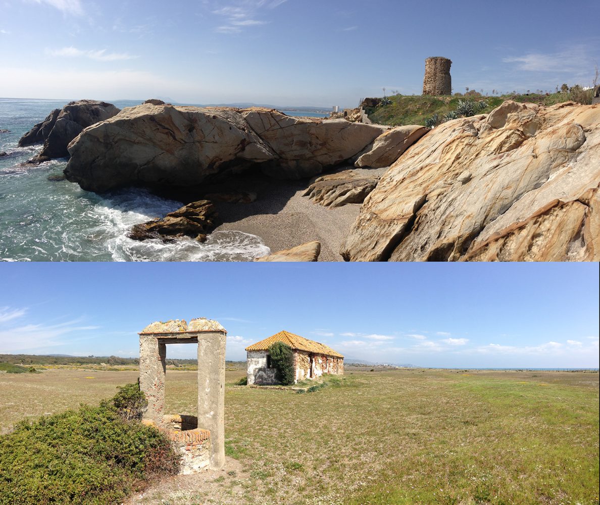
N-340 roadway corridor project. Mar Loren Méndez - Principal researcher. Existence of heritage assets in the corridor prior to motorized traffic. Restored watchtower, Salto La Mora, Casares (Malaga) and military quarters of the ‘carabineros,’ Guadalquitón Dunes, San Roque (Cádiz) April 2015. N-340 Research Team.

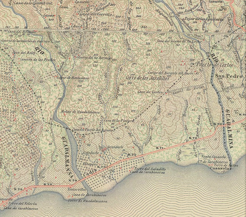
N-340 roadway corridor project Mar Loren Méndez - Principal researcher. Analysis of human activity in the corridor. Snapshot of corridor heritage prior to motorized traffic. National Topographic Map produced by the German Army, detail of sheet 1072, scale 1:50.000, first edition, 1916 in National Geographic Institute (IGN), Ministry of Development, Government of Spain.

Geographical Information System (GIS) are a computer-based set of tools that work with georeferenced data using spatial or geographic coordinates (geodata) with practical purpose. Developed from the evolution of different software such as Databases Manager System (DMS), Computer-Aided Design (CAD), and image processing GIS works as a database where geometry and geographical representation associated to spatial data. From its beginning in 1960 the use of GIS focus in the environmental management and end up broadening to other fields with special implication in heritage. The use of GIS is spread around different field like surveying of environmental risk, climate monitoring, elaboration of maps and cartography or territorial analysis. Focusing on heritage and sustainability the construction of Spatial Data Infrastructure (SDI) stands out like the main tool where public and private institution promote the inclusion of different data at national and international level. The use of GIS in this field constitutes a net where tools, software and information are meshed and allow both professional and student to create, manage, analyse, and query any works around all types of spatial data.

Box, P. (1999). GIS and cultural resource management: a manual for heritage managers – UNESCO Digital Library. https://unesdoc.unesco.org/ark:/48223/pf0000116270

Capdevila Montes, E., & Mínguez García, M. del C. (2016). Introducción a los Sistemas de Información Geográfica. In M. del C. Míngez García & E. Capdevila Montes (Eds.), Manual de Tecnologías de la Información Geográfica aplicadas a la Arqueología (pp. 21–78). Comunidad de Madrid, Museo Arqueológico Regional; Ilustre Colegio Oficial de Doctores y Licenciados en Filosofía y Letras y en Ciencias de la Comunidad de Madrid. https://dialnet.unirioja.es/servlet/articulo?codigo=5543766

Fernández Cacho, S., & García Sanjuan, L. (2003). Los SIG en la tutela del Patrimonio Arqueológico de Andalucía. Jornadas Técnicas ‘Patrimonio y Territorio. Desarrollo de Estrategias En Entornos SIG”, 1–10. http://grupo.us.es/atlas/documentos/articulos/desarrollo_local/desarrollo_local.pdf

Ferreira-Lopes, P. (2018). Achieving the state of research pertaining to GIS applications for cultural heritage by a systematic literature review. International Archives of the Photogrammetry, Remote Sensing and Spatial Information Sciences – ISPRS Archives, 42(4), 249–252. https://doi.org/10.5194/isprs-archives-XLII-4-169-2018

Ferreira-Lopes, P. (2018). Modelos digitales de información -SIG y Grafos- aplicados en el patrimonio: la fábrica edilicia en el antiguo reino de Sevilla en el tránsito a la Edad Moderna. https://idus.us.es/handle/11441/81525

Ferreira-Lopes, P., & Pinto-Puerto, F. (2018). GIS and graph models for social, temporal and spatial digital analysis in heritage: The case-study of ancient Kingdom of Seville Late Gothic production. Digital Applications in Archaeology and Cultural Heritage, 9, e00074. https://doi.org/10.1016/J.DAACH.2018.E00074

Loren-Méndez, M., Pinzón-Ayala, D., Ruiz, R., & Alonso-Jiménez, R. (2018). Mapping Heritage: Geospatial Online Databases of Historic Roads. The Case of the N-340 Roadway Corridor on the Spanish Mediterranean. ISPRS International Journal of Geo-Information, 7(4), 134. https://doi.org/10.3390/ijgi7040134

Loren-Méndez, M., Mata-Olmo, R., Ruiz, R., & Pinzón-Ayala, D. (2016). An Interdisciplinary Methodology for the Characterization and Visualization of the Heritage of Roadway Corridors. Geographical Review, 106(4), 489–515. https://doi.org/10.1111/j.1931-0846.2016.12203.x

Mascort-Albea, E. J. (2018). Mapas para el patrimonio: caracterización técnica de las iglesias medievales de Sevilla mediante sistemas de información geográfica (SIG). https://idus.us.es/xmlui/handle/11441/70745

Author: Roberto F Alonso-Jiménez
Universidad de Sevilla

Add contribution

Your email address will not be published. Required fields are marked *